
3D Urban Planning Tools
Explore VU.CITY’s 3D urban planning tools, built to support clearer site feasibility, faster workflows, and better decision-making.
From Protected Views and precise height measurements to custom styles, terrain editing, and ZTV analysis, these features help you test design ideas, comply with policy, and engage stakeholders with confidence.


Explore VU.CITY's 3D development tools
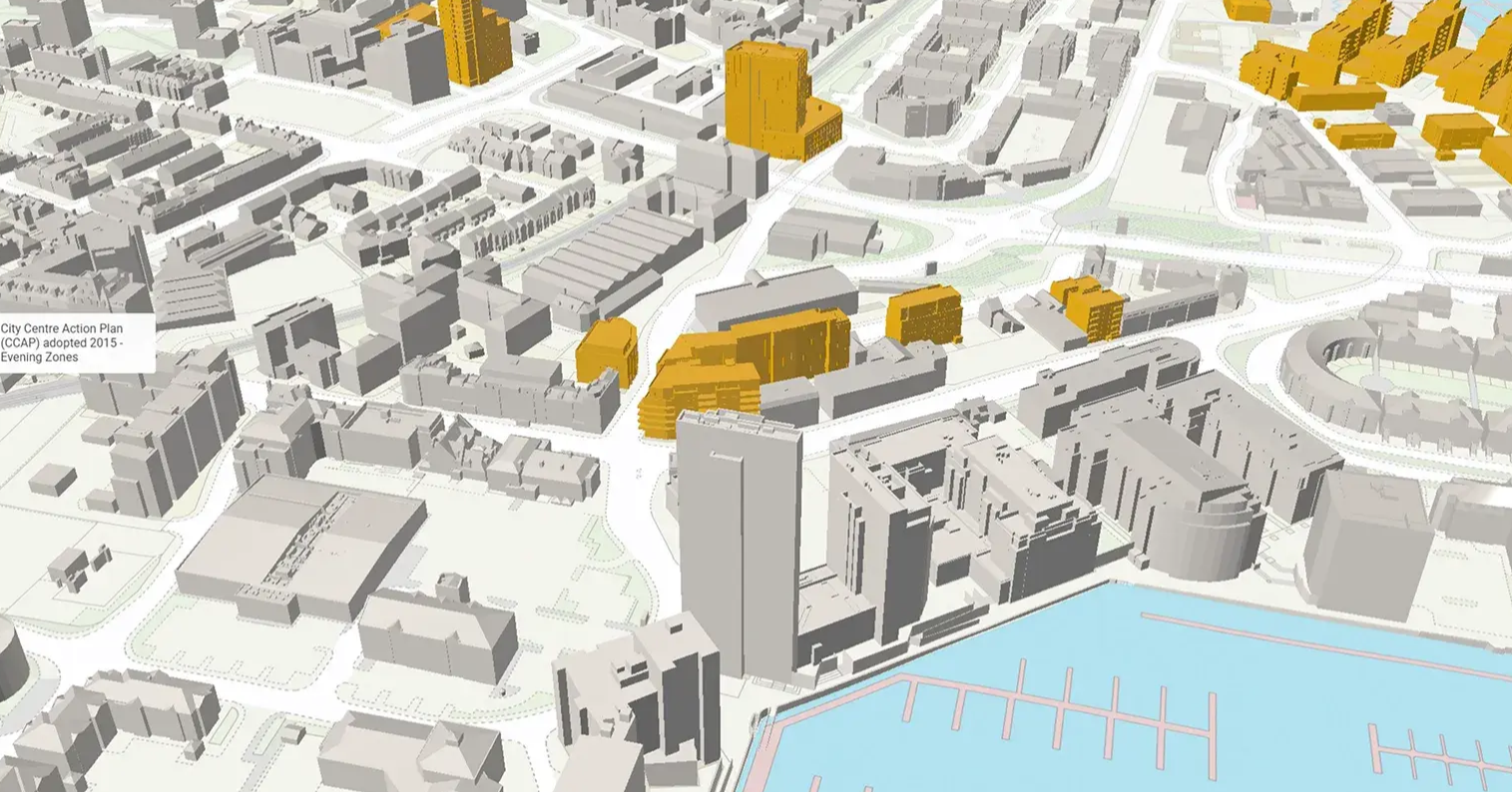
There are some important views across specific cities, from parks and other public spaces that take in important buildings, to urban landscapes that help culturally define the city.
These important views - known as Protected Views - are visualised in VU.CITY so that you can design schemes in these areas with clarity on aspects such as height restrictions.
Please note that available protected view frameworks vary from city to city, and within frameworks you may have varying view categories like panoramas and linear views.
Calculate Above Ordnance Datum (AOD), elevation, and distances in the model—useful for roofline checks, cut/fill assessments and mapping site topography.
Configure the settings so that you can use colour layers that flood the model up to the chosen height for AOD, or use a point system to measure distance, including elevation from sea level and map coordinates.
Change background and edge line colours, apply transparency levels, and save presets to personalise your visual outputs for presentations or design testing.
Easily save the configuration for future use and switch it on or off whenever you need to.
Focus attention with colour-coded highlights.
Quickly highlight selected buildings or areas with bright, visible colours to draw attention to key assets or proposals in your model.
Hide model elements to isolate your focus.
Temporarily remove trees, terrain, or buildings from view to simplify context, reduce noise, or zoom in on your site. The tool also automatically adjusts buildings when selected areas intersect with them, enabling seamless modifications.
Collaborate smarter with interactive tags.
Add comments, issues, or questions directly to the model using tags, ideal for stakeholder reviews, design coordination and feedback tracking.
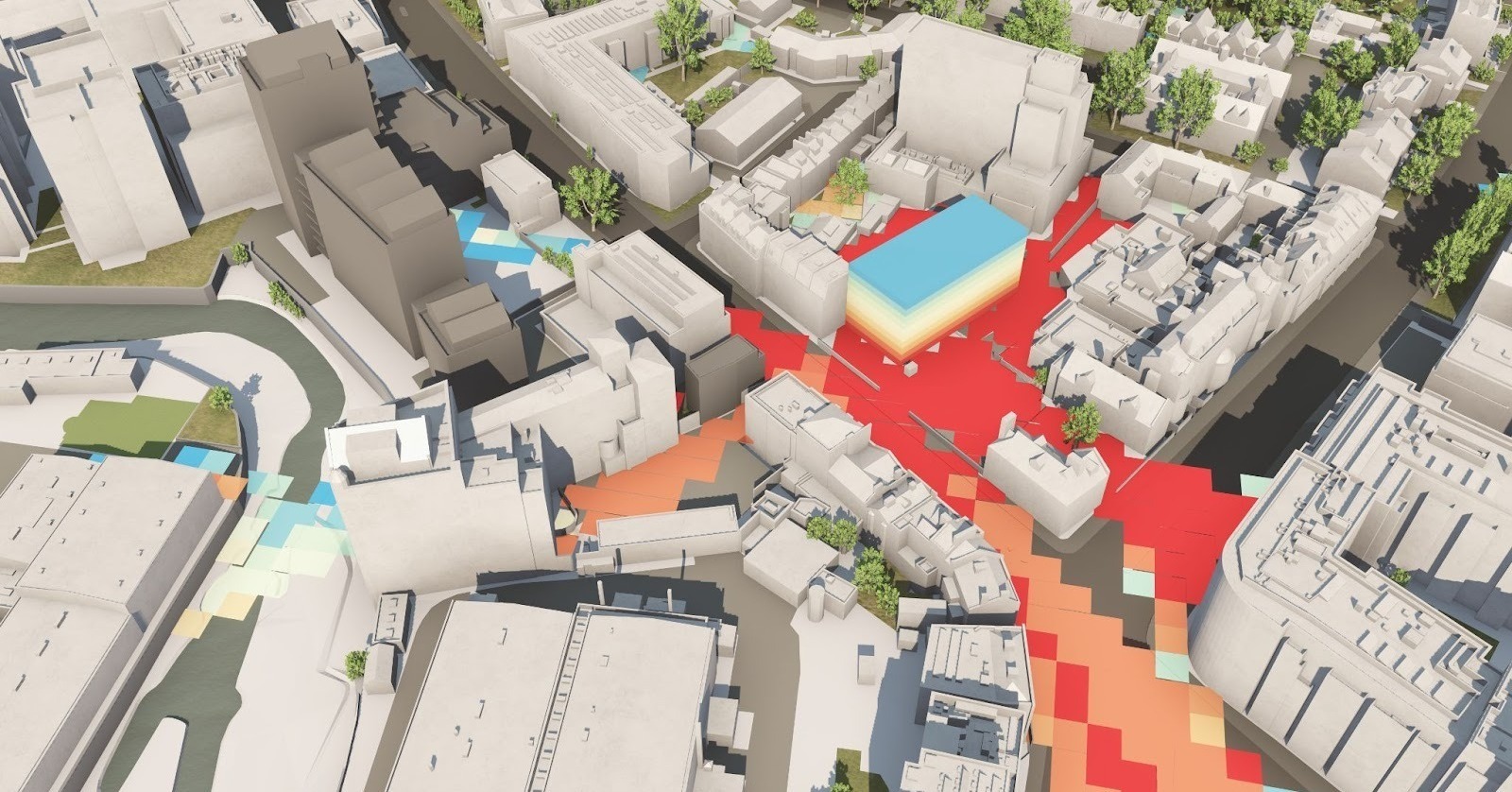
Run quick visibility checks with ZTV (Zone of Theoretical Visibility).
Instantly calculate what areas are visible from a specific point or building—essential for protected views, massing, and environmental impact analysis.
VU.CITY Case Studies
See how leading built environment experts are using VU.CITY
-1-1-1.png)
Urban Planning Tools FAQ
Frequently Asked Questions about VU.CITY's Urban Planning Tools.
What are VU.CITY's 3D urban planning tools?
Our suite of 3D urban planning tools is designed to help professionals interact with detailed digital city models. From accurate measurements to visual customisation, these tools—including Measure, Hide, Highlight, Style, Tag, and Analyze ZTV—empower you to plan, analyse, and collaborate more effectively on urban projects.
How does the Measure Tool support urban planning?
The Measure Tool provides precise calculations of distances and height offsets (also known as AOD) within your digital model. This ensures that every spatial dimension is accurately captured, allowing you to make informed, data-driven decisions throughout the planning process.
What is the Hide Tool and how does it simplify site preparation?
The Hide Tool allows you to selectively remove or hide specific elements—such as buildings, trees, or terrain—from your 3D model. This focused approach to site preparation helps you clear visual clutter and better visualise new developments or design modifications.
Am I able to showcase a sewer, plumbing system or underground car park?
Absolutely. You can do this using our Model Importer and the Hide Tool.
What 3D software features can plotted areas be exported into?
How does the Highlight Tool improve project communication?
The Highlight Tool enables you to emphasise key features or areas within your model. By drawing attention to critical design elements, this tool enhances clarity during presentations and collaborative reviews, ensuring that important aspects of your project stand out.
What is the Analyse ZTV feature and how does it support planning decisions?
Analyse ZTV assesses the theoretical visibility and visual impact of your project within its urban context, offering valuable insights for planning and design. For more details on this feature, please visit our dedicated ZTV page.
Trusted by 6,000+ users across 26 cities
Architects, developers, local authorities, urban planners, and more trust VU.CITY to help achieve their goals.
Organise and visualise your geospatial data in accurate context with our comprehensive suite of digital design and development tools.
26 UK & International Cities
Over 3,000+ sq km accurate to 15cm | Tools to scope, create & collaborate on designs
VU.CITY seamlessly integrates with leading 3D digital software for an easy fit into existing workflows.
We are compatible with the biggest 3D software providers so that you can focus on your designs and plans with minimal disruption.
SiteSolve is our early-stage site exploration and generative design tool. Find out more.

Optimise FBX exports from Revit with our VU.CITY Revit Plugin and Update Agent. Embed materials, maintain positioning, and more.
Export SKP models to FBX using our VU.CITY SketchUp Plugin (beta). Produce FBX files optimised for use in VU.CITY.
Optimise and fix common issues with FBX models using our VU.CITY Blender Add-in. It's the best model editor we've come across.
Explore digital 3D geospatial solutions for the built environment
VU.CITY provides clear, powerful tools for key decision-makers across the built environment, helping them visualise and shape the future of cities with confidence and precision.
Make smarter decisions with data-driven insights, from infrastructure to sustainability.
Unlock the power of Generative AI for optimal design and streamlined decision-making.
Bring your designs to 3D life with state-of-the-art modelling tools.
Collaborate seamlessly across studies, planning, and design.
Utilise advanced 3D models and a data-driven approach with our flexible ZTV service.
Bring Your Vision to Life with a 3D Flythrough Video.
Shape Tomorrow’s Cities, Today.
Begin Your Free Trial Now.
