
Camera Tools
Choose multiple angles and camera settings, showcase detailed viewshed analysis, dynamic feasibility studies, and immersive visuals that captivate stakeholders—perfect for bids, design meetings, and planning presentations.


Explore VU.CITY's 3D camera tools
Set custom camera angles, focal lengths, and perspectives to explore your scheme in detail.
Perfect for spatial testing, design evaluation, and aligning teams around a shared visual truth.
Generate high-quality 360 panoramas of your development.
Share interactive viewpoints with clients, stakeholders, and planning teams—ideal for early engagement and consultation.
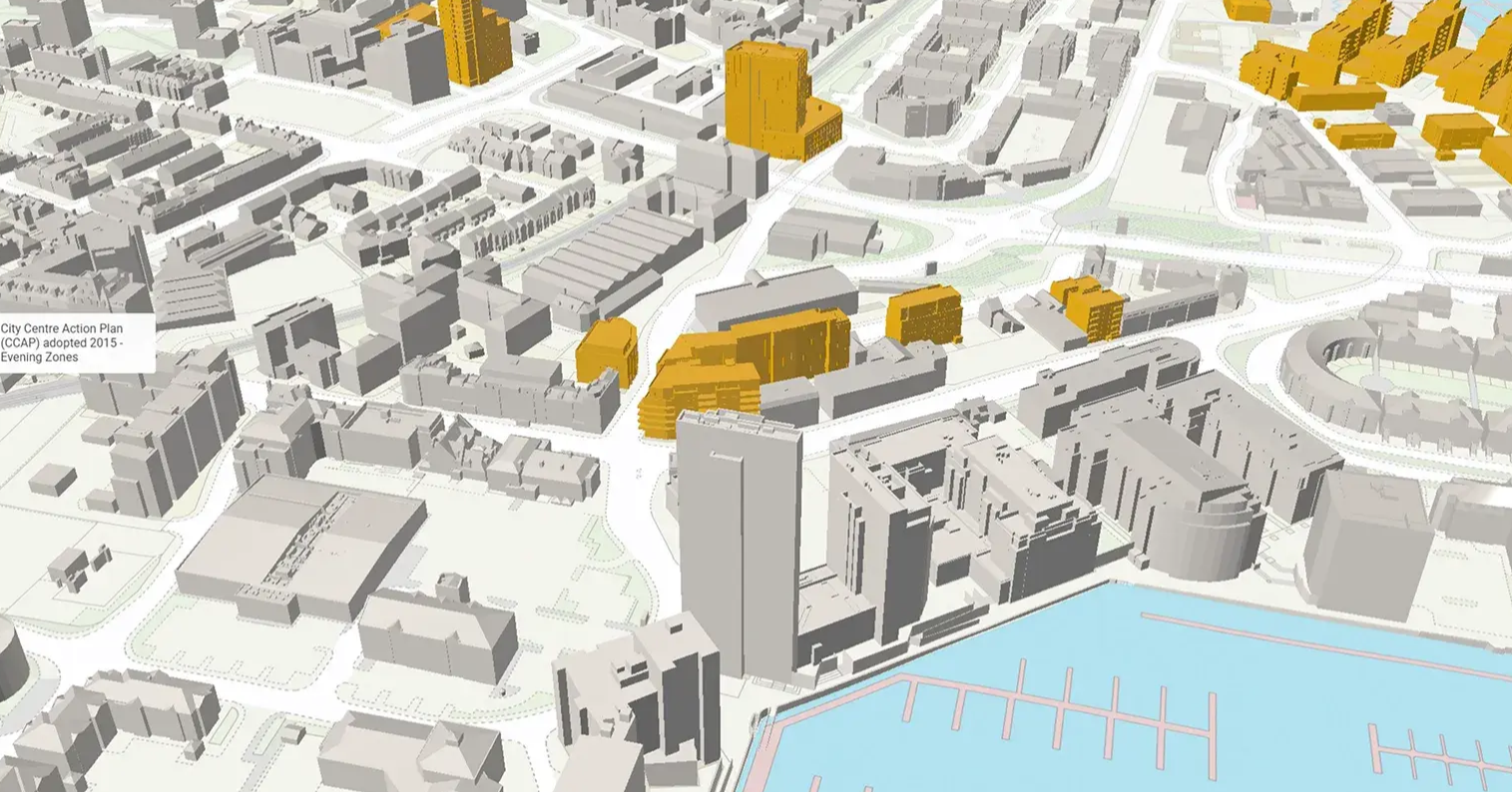
Toggle model elements to focus your view.
Hide or reveal specific layers of the model—like consented schemes or massing studies—to highlight what matters. Simplify complex views and tailor presentations to your audience.
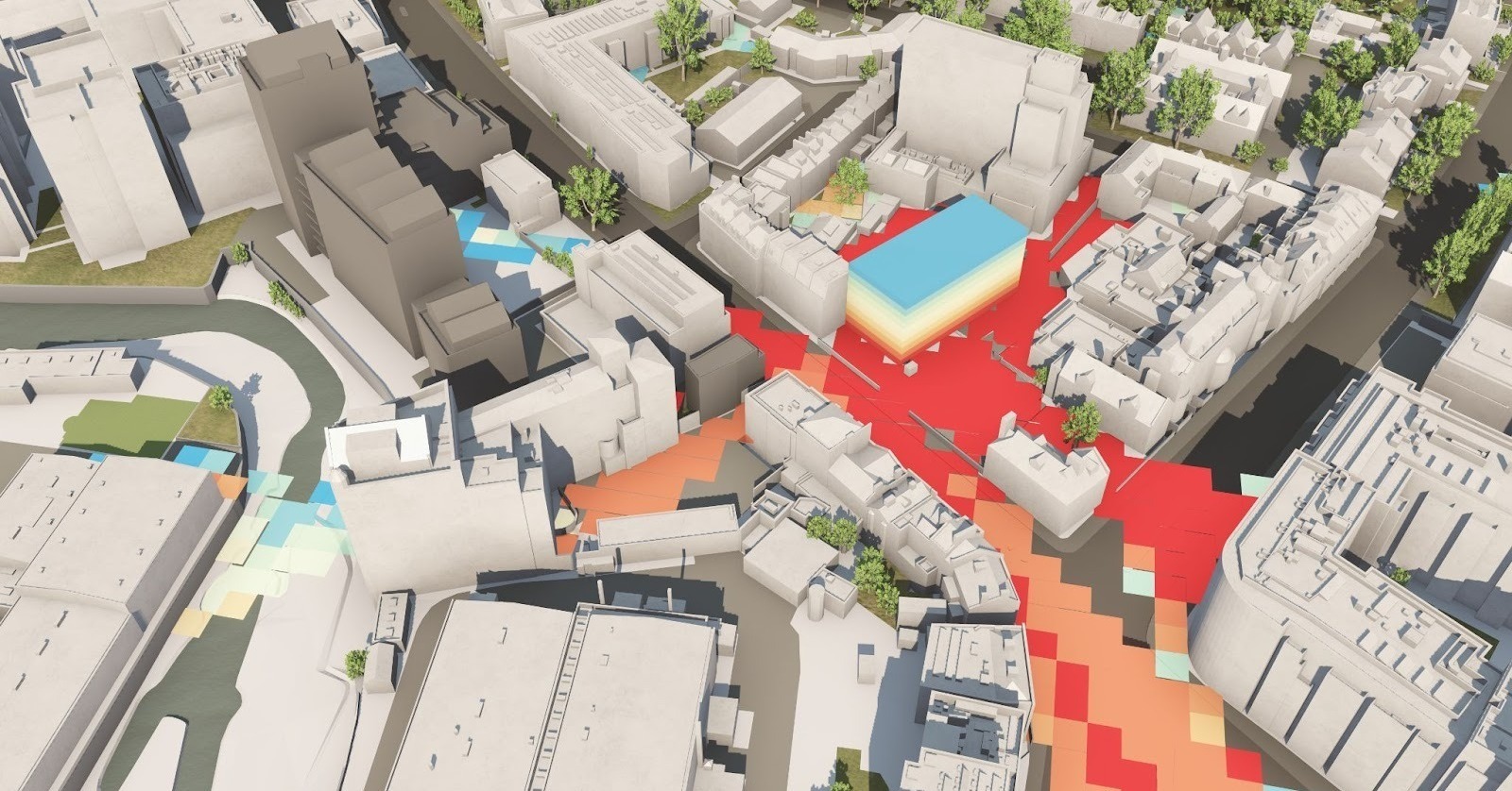
Analyse line-of-sight and visibility across your site or city with precision.
Our Viewshed tool helps test visual impact, strategic views, and compliance with protected view corridors.
Present projects seamlessly in 3D.
Switch to presentation mode for polished, guided walkthroughs of your model. Ideal for pre-app meetings, public consultations, design reviews and client showcases.
Capture and share visual evidence instantly.
Take high-resolution screenshots from any angle for reports, planning applications or stakeholder packs.
Record custom videos and animated views of your proposal within the model. These videos help win bids, secure buy-in, and simplify complex designs for non-experts.
Export images and video directly from your model for fast, consistent visuals.
VU.CITY Case Studies
See how leading built environment experts are using VU.CITY
-1-1-1.png)
Camera Tools FAQ
Frequently Asked Questions about VU.CITY's Camera Tools.
What are VU.CITY's Camera Tools?
Our camera tools are advanced 3D city model presentation tools designed for urban planning. They enable you to capture, analyse, and present detailed visuals of your projects, including viewshed analysis and feasibility study visualisations, with high-resolution image and video exports.
How do the camera tools support viewshed analysis?
VU.CITY’s camera tools allow you to perform detailed viewshed analysis by simulating realistic perspectives. This functionality helps you understand sightlines, assess visual impacts, and determine how buildings and other elements interact with their surroundings—all critical for effective urban planning.
Can I export images and videos with these tools?
Yes, our camera tools offer robust export options that allow you to generate high-quality images and video walkthroughs of your 3D city models. These exports are perfect for presentations, stakeholder meetings, bids, and planning committee submissions.
Who can benefit from using these urban planning camera tools?
Our camera tools are designed for a wide range of built environment professionals—including architects, urban planners, developers, and local authorities. Whether you’re refining design concepts or presenting project proposals, these tools help you deliver clear, compelling visual narratives.
What makes VU.CITY's 3D city model presentation tools unique?
VU.CITY’s camera tools stand out by combining precise viewshed analysis with advanced export capabilities, all within an interactive platform. This integration ensures that every visual element—from realistic perspectives to dynamic feasibility studies—is both data-driven and presentation-ready, enhancing collaboration and decision-making.
How do I get started with VU.CITY's urban planning camera tools?
Getting started is simple. Contact our team for a demo or consultation, or fill in the form below, and we’ll walk you through the platform’s features. Once onboard, you can begin leveraging our camera tools to capture immersive visuals and transform how you present and collaborate on 3D city models.
Explore digital 3D geospatial solutions for the built environment
VU.CITY provides clear, powerful tools for key decision-makers across the built environment, helping them visualise and shape the future of cities with confidence and precision.
Make smarter decisions with data-driven insights, from infrastructure to sustainability.
Unlock the power of Generative AI for optimal design and streamlined decision-making.
Bring your designs to 3D life with state-of-the-art modelling tools.
Collaborate seamlessly across studies, planning, and design.
Utilise advanced 3D models and a data-driven approach with our flexible ZTV service.
Bring Your Vision to Life with a 3D Flythrough Video.
26 UK & International Cities
Over 3,000+ sq km accurate to 15cm | Tools to scope, create & collaborate on designs
Shape Tomorrow’s Cities, Today.
Begin Your Free Trial Now.
