
Model Controls
Customise your digital twin experience in VU.CITY with intuitive model controls. Explore cities with precision using tools designed for professionals in planning, design, and development.


Explore VU.CITY's 3D model control tools
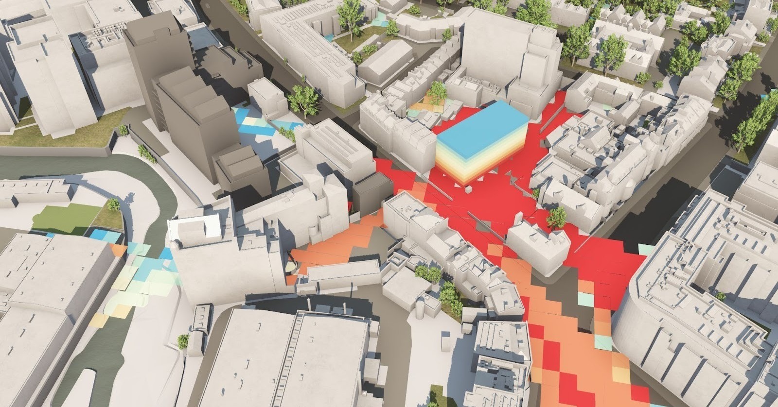
In VU.CITY, we have always applied a perspective projection when viewing our accurate models.
While this approach is generally appropriate and aesthetically pleasing (because it simulates a camera lens), it's not always ideal for the planning process.
Architects, planners, and landscapers often need imagery and diagrams without distortion. That's where our 2D Mode tool - the pinnacle of 2D orthographic projection in the business - comes in.
Control how much of the 3D model loads at once.
Tile loading helps you balance detail and performance—ideal for reviewing large city areas without lag.
This feature is essential for architects, planners, and developers needing a smooth, responsive experience during feasibility studies or live presentations.
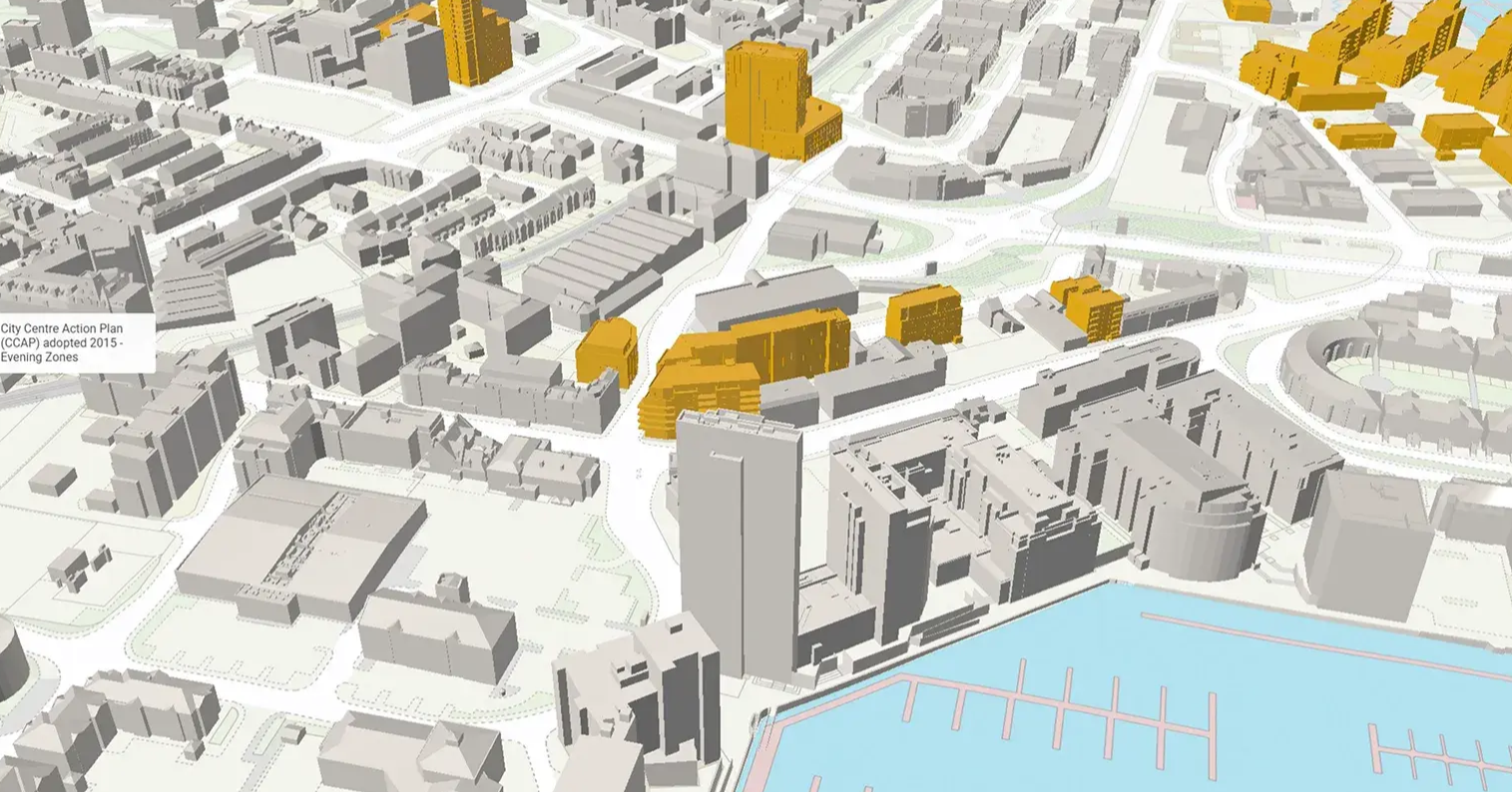
Toggle the visibility of trees and their foliage to focus on structural elements or gain insights into green space impact.
Ideal for Right of Light analysis, view assessments, and understanding how natural elements affect urban planning decisions.
Enable or disable shadows to assess how light interacts with the built environment.
Perfect for daylight impact studies, massing evaluations, and planning applications that require accurate environmental modelling.
VU.CITY Case Studies
See how leading built environment experts are using VU.CITY
-1-1-1.png)
VU.CITY seamlessly integrates with leading 3D digital software for an easy fit into existing workflows.
We are compatible with the biggest 3D software providers so that you can focus on your designs and plans with minimal disruption.
SiteSolve is our early-stage site exploration and generative design tool. Find out more.

Optimise FBX exports from Revit with our VU.CITY Revit Plugin and Update Agent. Embed materials, maintain positioning, and more.
Export SKP models to FBX using our VU.CITY SketchUp Plugin (beta). Produce FBX files optimised for use in VU.CITY.
Optimise and fix common issues with FBX models using our VU.CITY Blender Add-in. It's the best model editor we've come across.
Trusted by 6,000+ users across 26 cities
Architects, developers, local authorities, urban planners, and more trust VU.CITY to help achieve their goals.
Organise and visualise your geospatial data in accurate context with our comprehensive suite of digital design and development tools.
26 UK & International Cities
Over 3,000+ sq km accurate to 15cm | Tools to scope, create & collaborate on designs
Model Controls FAQ
Frequently Asked Questions about VU.CITY's Model Controls.
What is 2D orthographic projection in VU.CITY?
2D orthographic projection is a feature we call ‘2D mode’, which renders interactive city models without perspective distortion, ensuring all elements are displayed at their true scale. This mode is ideal for technical drawings, accurate measurements, and detailed planning.
What are some of the features and tools in VU.CITY’s 2D mode?
Users will benefit from several features designed to enhance their planning and analysis capabilities with 2D mode, including:
- New Camera Panel Controls
- Compass Button and Keyboard Shortcuts
- Save Views in the Camera Study Panel
In terms of the tools, these include Tile loading range, Tile loading on/off, Trees on/off, Leaves on/off, Shadows on/off, and Search.
How does 2D orthographic projection differ from the perspective view?
While perspective view simulates depth by reducing the size of distant objects, 2D orthographic projection eliminates distortion, presenting every element uniformly regardless of distance. This provides a clear, distortion-free image essential for precision work.
Who benefits from using 2D orthographic projection?
Architects, urban planners, developers, and local authorities all benefit from the clarity and accuracy of 2D orthographic projection. It supports technical design, planning submissions, and integration with GIS, making it a versatile tool for various urban planning professionals.
What are the key advantages of using interactive city models in 2D orthographic projection?
Interactive city models in 2D orthographic projection offer true-to-scale renderings, precise measurements, and an accurate depiction of spatial relationships. This enhances technical planning, facilitates detailed analyses, and supports seamless communication between project stakeholders.
How does 2D orthographic projection support planning and design processes?
By eliminating perspective distortion, 2D orthographic projection provides a reliable basis for technical drawings and accurate site analysis. This mode ensures that planning submissions and design documents meet rigorous accuracy requirements, ultimately improving project outcomes.
Can I switch between perspective view and 2D orthographic projection in VU.CITY?
Yes, VU.CITY offers flexible model controls that allow you to toggle between perspective and 2D orthographic projection. This feature enables you to choose the best view for your current task—whether you need a realistic overview or a precise, distortion-free diagram.
Explore digital 3D geospatial solutions for the built environment
VU.CITY provides clear, powerful tools for key decision-makers across the built environment, helping them visualise and shape the future of cities with confidence and precision.
Make smarter decisions with data-driven insights, from infrastructure to sustainability.
Unlock the power of Generative AI for optimal design and streamlined decision-making.
Bring your designs to 3D life with state-of-the-art modelling tools.
Collaborate seamlessly across studies, planning, and design.
Utilise advanced 3D models and a data-driven approach with our flexible ZTV service.
Bring Your Vision to Life with a 3D Flythrough Video.
Shape Tomorrow’s Cities, Today.
Begin Your Free Trial Now.
