
Microclimate Modelling Assessment
Simulate how your proposed development will be affected by environmental conditions—across any season, time of day, or weather scenario.
These tools help professionals analyse sun paths, weather impact, and atmospheric change in seconds, allowing for faster, more accurate decisions.


Explore VU.CITY's 3D microclimate analysis tools
Quickly simulate how sunlight interacts with your scheme across different times of day and seasons.
Ideal for daylight and sunlight assessments, Right of Light analysis, and optimising design for amenity, comfort, or planning requirements.
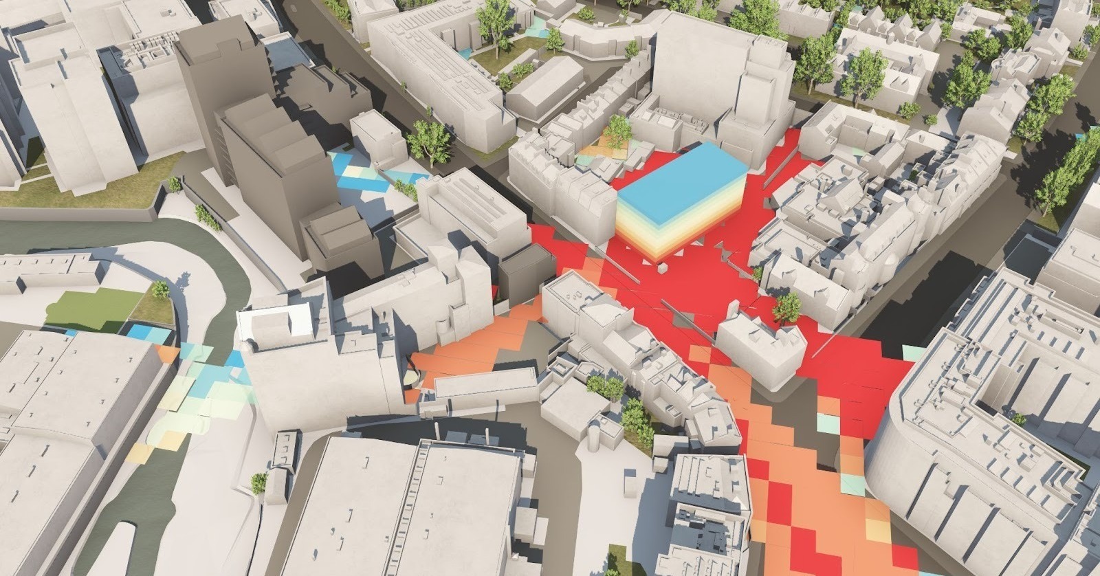
Simulate wind and weather patterns to understand how your development performs in different climatic conditions.
Use real-world data to assess pedestrian comfort, wind tunnelling, and public realm usability.
Visualise fog, glare, and other atmospheric effects that may impact your site.
Use this to improve visual impact assessments and create more accurate planning visuals.
VU.CITY Case Studies
See how leading built environment experts are using VU.CITY
-1-1-1.png)
VU.CITY seamlessly integrates with leading 3D digital software for an easy fit into existing workflows.
We are compatible with the biggest 3D software providers so that you can focus on your designs and plans with minimal disruption.
SiteSolve is our early-stage site exploration and generative design tool. Find out more.

Optimise FBX exports from Revit with our VU.CITY Revit Plugin and Update Agent. Embed materials, maintain positioning, and more.
Export SKP models to FBX using our VU.CITY SketchUp Plugin (beta). Produce FBX files optimised for use in VU.CITY.
Optimise and fix common issues with FBX models using our VU.CITY Blender Add-in. It's the best model editor we've come across.
Microclimate Tools FAQ
Frequently Asked Questions about VU.CITY's Microclimate Tools.
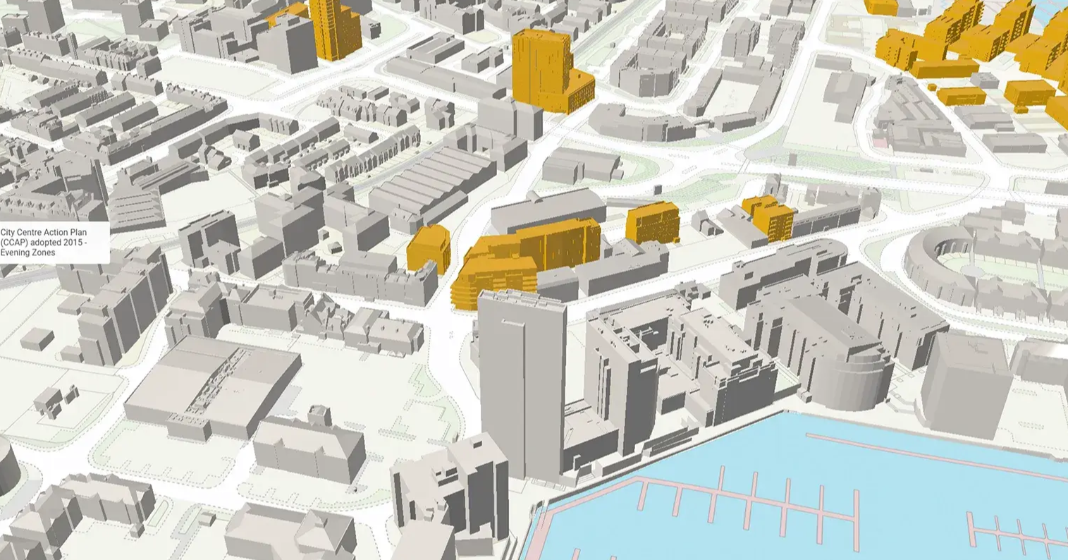
What is microclimate modelling and why is it important?
Microclimate modelling simulates localised weather conditions—such as sunlight, wind flow, and temperature variations—at a site-specific level. VU.CITY’s platform uses this data to help professionals understand how environmental factors interact with urban designs, ensuring that projects are both sustainable and optimised for natural conditions.
How does VU.CITY integrate environmental analysis with microclimate modelling?
Our tools combine detailed microclimate simulations with comprehensive environmental analysis. This integration presents actionable insights on solar access, wind patterns, and thermal performance, enabling architects, developers, planners, and local authorities to make data-driven decisions that improve project outcomes.
How can architects benefit from these climate tools?
Architects can leverage our climate modelling to simulate daylight and shadow patterns, optimise window and balcony placements, and refine building orientations. This precise data supports energy-efficient designs and helps ensure that aesthetic and functional aspects of a project harmonise with its environmental context.
In what ways do developers use VU.CITY’s climate tools to enhance project viability?
Developers can assess site potential by evaluating microclimatic factors such as sunlight exposure, wind flow, and thermal conditions. With these insights, they can optimise building placements, reduce operational costs, and design projects that not only attract investment but also perform sustainably over time.
What advantages do urban planners gain from accurate climate modelling?
Urban planners benefit by gaining a clearer picture of local environmental dynamics. Our tools help simulate scenarios for solar access and heat distribution, supporting strategic decisions on zoning, infrastructure development, and green space allocation—all of which contribute to more resilient and livable urban environments.
How do local authorities use these climate tools in planning and compliance?
Local authorities utilise our platform to assess the environmental impact of proposed developments, ensuring compliance with daylight and energy standards. The detailed, distortion-free imagery and data support transparent decision-making, streamlined planning submissions, and effective communication with stakeholders and communities.
How can I get started with VU.CITY’s microclimate modelling and environmental analysis tools?
Getting started is easy. Fill in the information below to get a quote and a free demo. If you prefer you can contact us and our experts will guide you through the platform’s features, showing you how to integrate precise climate data into your planning and design processes for improved outcomes.
26 UK & International Cities
Over 3,000+ sq km accurate to 15cm | Tools to scope, create & collaborate on designs
Trusted by 6,000+ users across 26 cities
Architects, developers, local authorities, urban planners, and more trust VU.CITY to help achieve their goals.
Organise and visualise your geospatial data in accurate context with our comprehensive suite of digital design and development tools.
Explore digital 3D geospatial solutions for the built environment
VU.CITY provides clear, powerful tools for key decision-makers across the built environment, helping them visualise and shape the future of cities with confidence and precision.
Make smarter decisions with data-driven insights, from infrastructure to sustainability.
Unlock the power of Generative AI for optimal design and streamlined decision-making.
Bring your designs to 3D life with state-of-the-art modelling tools.
Collaborate seamlessly across studies, planning, and design.
Utilise advanced 3D models and a data-driven approach with our flexible ZTV service.
Bring Your Vision to Life with a 3D Flythrough Video.
Shape Tomorrow’s Cities, Today.
Begin Your Free Trial Now.
