
How do you grow taller without losing what matters?
Cities around the world are facing a shared challenge: how do we accommodate vertical growth without compromising our cultural and visual heritage? From London's St. Paul’s Cathedral to the Eiffel Tower in Paris and the Empire State Building in New York, preserving sightlines to iconic landmarks is critical for civic identity, tourism, and good urban planning.
Enter Zones of Theoretical Visibility (ZTVs) and 3D height modelling; tools that empower planners, architects, and local authorities with the data to see clearly, plan confidently, and protect strategically.
The Balancing Act: Height vs Heritage
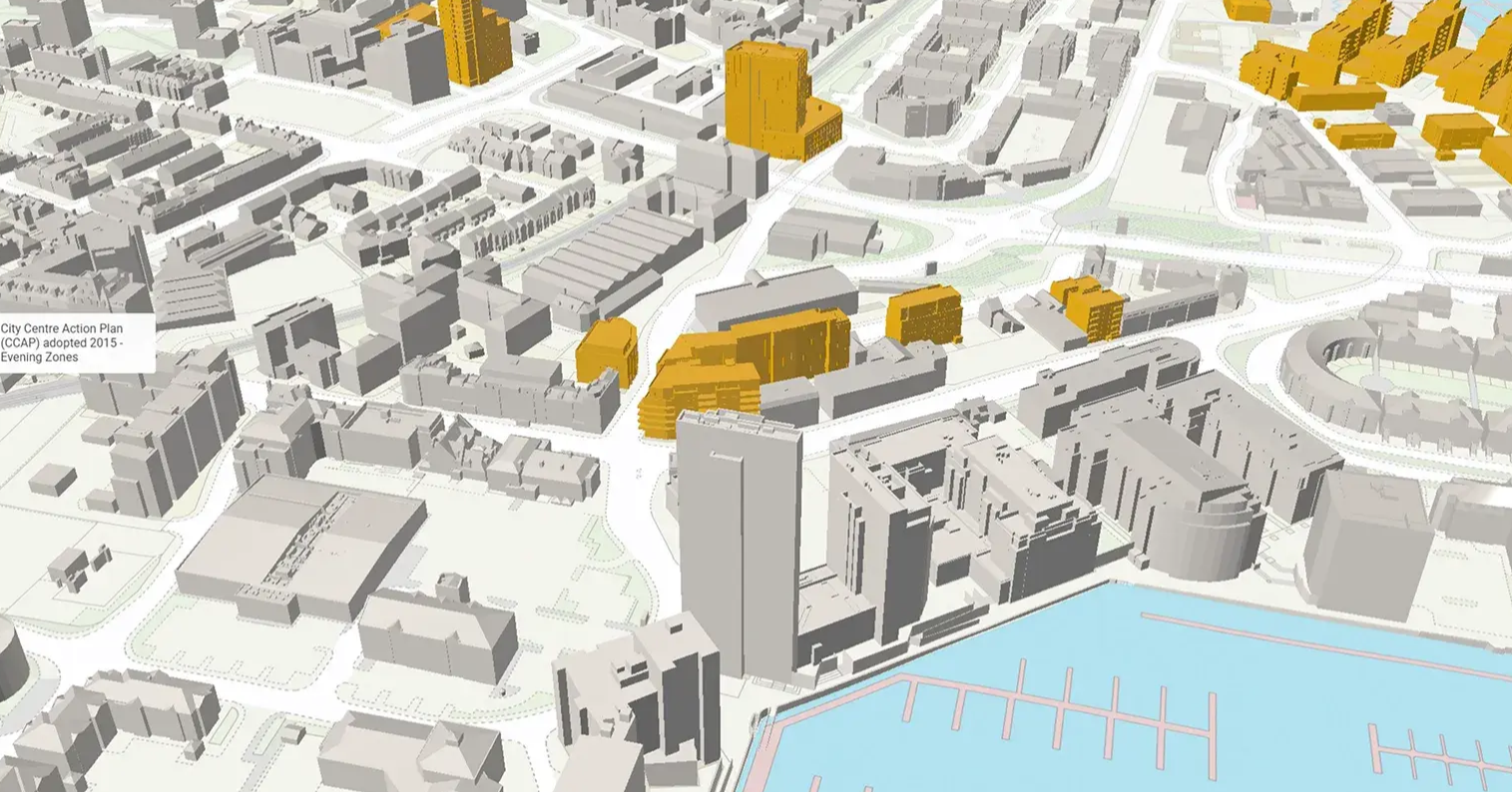
Rapid development in central urban areas brings with it the pressure to build upwards. Tall buildings unlock more office space, housing, and infrastructure—but without careful view planning, they can unintentionally obstruct protected sightlines or diminish the visual importance of historic landmarks.
This is especially true in places like:
-
London, where the London View Management Framework (LVMF) governs protected views of St Paul’s, Tower Bridge, and Parliament Hill.
-
Paris, where building height caps exist to preserve views of the Eiffel Tower and Sacré-Cœur.
-
New York, where visual corridors are vital to maintaining the skyline’s identity.
To navigate this, planners are increasingly using ZTV analysis, a tool that calculates the potential visibility of a development from key vantage points.
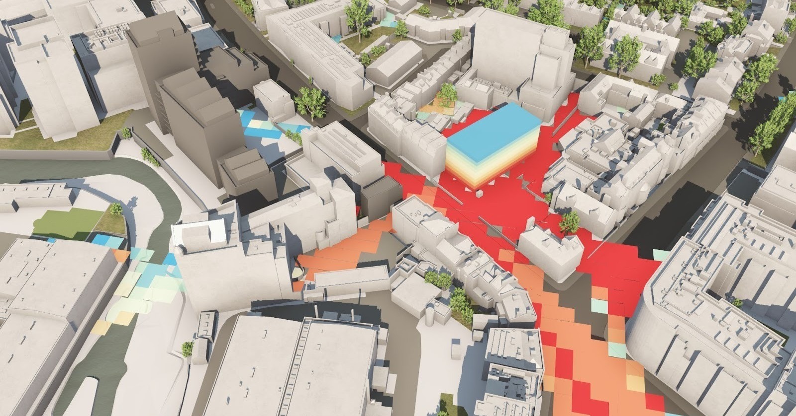
Understanding Zones of Theoretical Visibility (ZTVs)
A Zone of Theoretical Visibility (ZTV), also known as a Zone of Visual Influence (ZVI), is a computer-generated tool used to identify the likely extent of visibility of a development. By analysing the elevation of a proposed development against a 3D terrain model, ZTVs help planners and developers understand where a building would be visible from, aiding in visual impact assessments.

2km example with Heat Map
The Role of the London View Management Framework (LVMF)
In London, the London View Management Framework (LVMF) plays a pivotal role in protecting key views of the city's landmarks. The LVMF outlines strategic views that must be preserved, guiding development to ensure that new buildings do not obstruct these important sightlines.
VU.CITY's Approach to View Preservation
VU.CITY offers advanced tools that integrate ZTV analysis within a comprehensive 3D city model. This integration allows for:
-
Accurate Visual Impact Assessments: Quickly determine where a proposed development would be visible from, aiding in early-stage planning decisions.
-
Enhanced Stakeholder Engagement: Visual tools facilitate clearer communication among planners, developers, and the public.
-
Informed Decision-Making: Data-driven insights support balanced development that respects both growth and heritage preservation.
🔎 Example: In the City of London, VU.CITY worked with the Corporation to create a detailed 3D "jelly mould" model and accompanying ZTV analysis to guide the future development of the City Cluster—preserving views of St. Paul's while accommodating new high-rise offices.
👉 Read the case study
Example: Protecting Views of St. Paul's Cathedral
St. Paul's Cathedral is one of London's most iconic landmarks. Protecting its visibility has been a priority for city planners. By utilising ZTVs and adhering to guidelines set by the LVMF, developments are carefully assessed to ensure they do not intrude upon the protected vistas of the cathedral.
Watch the video below to view the LVMF of St. Pauls Cathedral.
Conclusion
Balancing urban development with the preservation of historic views is a delicate task. Tools like ZTVs and comprehensive 3D modelling platforms such as VU.CITY provide the necessary insights to make informed decisions, ensuring that cities can grow while maintaining their unique identities.
Ready to Protect Your Views?
Whether you're working on a new tower, assessing visual impact, or planning in a sensitive location, our ZTV analysis gives you the data you need to make smart, informed decisions.
👉 Request a ZTV and see how your proposed development will impact protected views.
VU.CITY Case Studies
See how leading built environment experts are using VU.CITY
-1-1-1.png)
Shape Tomorrow’s Cities, Today.
Begin Your Free Trial Now.
