
For
in
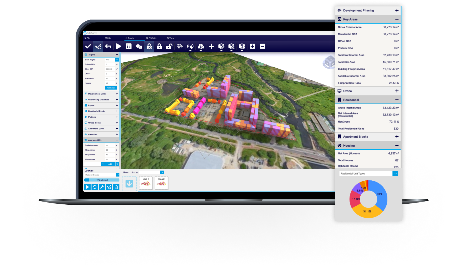
Create ideas and test them – from one building to a masterplan. Share your vision, wow clients, and move from conception to completion with confidence.

Trusted by 6,000+ users across 26 cities
Architects, developers, local authorities, urban planners, and more trust VU.CITY to help achieve their goals.
Organise and visualise your geospatial data in accurate context with our comprehensive suite of digital design and development tools.
3D digital twin
VU.CITY Belfast's functionality and rich data layers help reduce design and planning uncertainty, highlight potential impact and speed up crucial decisions
With VU.CITY accurate, interactive and immersive 3D digital model of Belfast all stakeholders can collaborate on solutions for smarter decisions and project success.
26 UK & International Cities
Over 3,000+ sq km accurate to 15cm | Tools to scope, create & collaborate on designs
Generative 3D Design for the Built Environment
VU.CITY seamlessly integrates with leading 3D digital software for an easy fit into existing workflows.
We are compatible with the biggest 3D software providers so that you can focus on your designs and plans with minimal disruption.
SiteSolve is our early-stage site exploration and generative design tool. Find out more.

Optimise FBX exports from Revit with our VU.CITY Revit Plugin and Update Agent. Embed materials, maintain positioning, and more.
Export SKP models to FBX using our VU.CITY SketchUp Plugin (beta). Produce FBX files optimised for use in VU.CITY.
Optimise and fix common issues with FBX models using our VU.CITY Blender Add-in. It's the best model editor we've come across.
IN YOUR WORDS
"VU.CITY allows us to convey ideas when physical engagement is not possible, assisting the decision-making process in a way in which all stakeholders can relate to the proposal and its impact in the surroundings."

"Development and architecture are embracing technology at a rapid rate but many ideas are impractical or premature and don’t work. The VU.CITY platform is already making an essential difference to design and planning decisions in London and clearly will go much further."

“Only very rarely do I come across a product that when I first see it I’m left wondering how we ever coped without it - VU.CITY is one of those products.”
"The students were greatly helped by exploring their conceptual designs in their urban context by using VU.CITY’s accurate and immersive city model of London. It gives them greater understanding of their chosen sites and enhances their ability to portray their architectural ideas visually."

"VU.CITY is helping us analyse projects at an early stage and refine elements of our live projects faster and more accurately. Being able to quickly assess a site or stress test things like massing and planning context provides us with more clarity and objectivity that would previously have taken us a lot longer to achieve."

Explore digital 3D geospatial solutions for the built environment
VU.CITY provides clear, powerful tools for key decision-makers across the built environment, helping them visualise and shape the future of cities with confidence and precision.
Make smarter decisions with data-driven insights, from infrastructure to sustainability.
Unlock the power of Generative AI for optimal design and streamlined decision-making.
Bring your designs to 3D life with state-of-the-art modelling tools.
Collaborate seamlessly across studies, planning, and design.
Utilise advanced 3D models and a data-driven approach with our flexible ZTV service.
Bring Your Vision to Life with a 3D Flythrough Video.