
.png?width=800&height=400&name=63ff5d9d26550e76cbed0ccb_Harriet%20News%20Item%20Blog%20(2).png) The digitisation of planning has been a mainstay of future reforms of the planning system for some years, and it’s widely acknowledged that the adoption of digital tools can have a significant and powerful impact on the way we design our places and buildings.
The digitisation of planning has been a mainstay of future reforms of the planning system for some years, and it’s widely acknowledged that the adoption of digital tools can have a significant and powerful impact on the way we design our places and buildings.
Back in 2019 Sam Stafford’s much celebrated “50 Shades of Planning Podcast” featured an episode with Euan Mills, discussing data, planning, and the case for technological advancement in the planning sector. At the time, Sam and Euan spoke about the innovative stance of Southwark Council - requesting 3D models with every major planning application. A few other pioneering planning authorities were starting to follow suit.
The landscape of the adoption of 3D technology, just over three years and a half down the line, is very different. Many forward thinking local planning authorities are looking at how they can leverage this type of technology to help them with both the formation of strategic planning as well as development management.
Strategic Planning
Many local authorities have recognised that using 3D models allows them to test and analyse their proposed policies, as they go through the stages of formation. This is particularly true for local planning authorities looking to inform their site allocations and tall building policies.
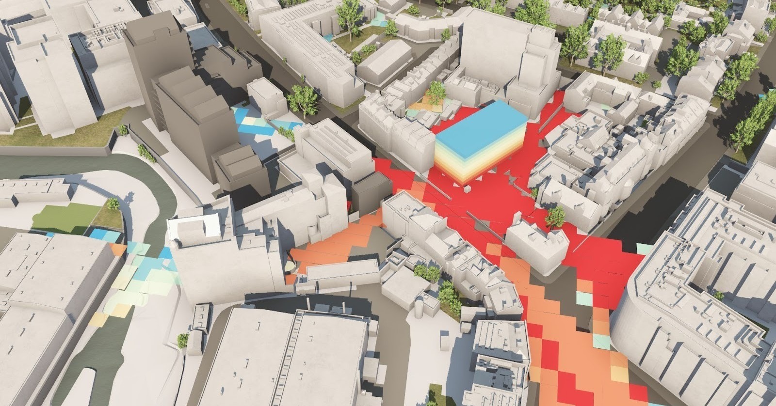
After undertaking a sifting exercise to identify potential appropriate sites, using 3D modelling allows for different scenarios to be simulated and tested, to ensure that proposals are sensitive to a local area, and can be fully analysed for impact, across the borough. The London Plan 2021 in fact promotes the use of 3D modelling to identify tall building locations, as well as the use of such technology where possible to be used to inform plan-making, decision-taking and public engagement.
Historic England also encourages the use of 3D modelling in their Advice Note 4, in cases where the potential impact of tall building proposals need to be understood, including options analysis, and also supports the use of 3D modelling where protected views need to be analysed or considered.
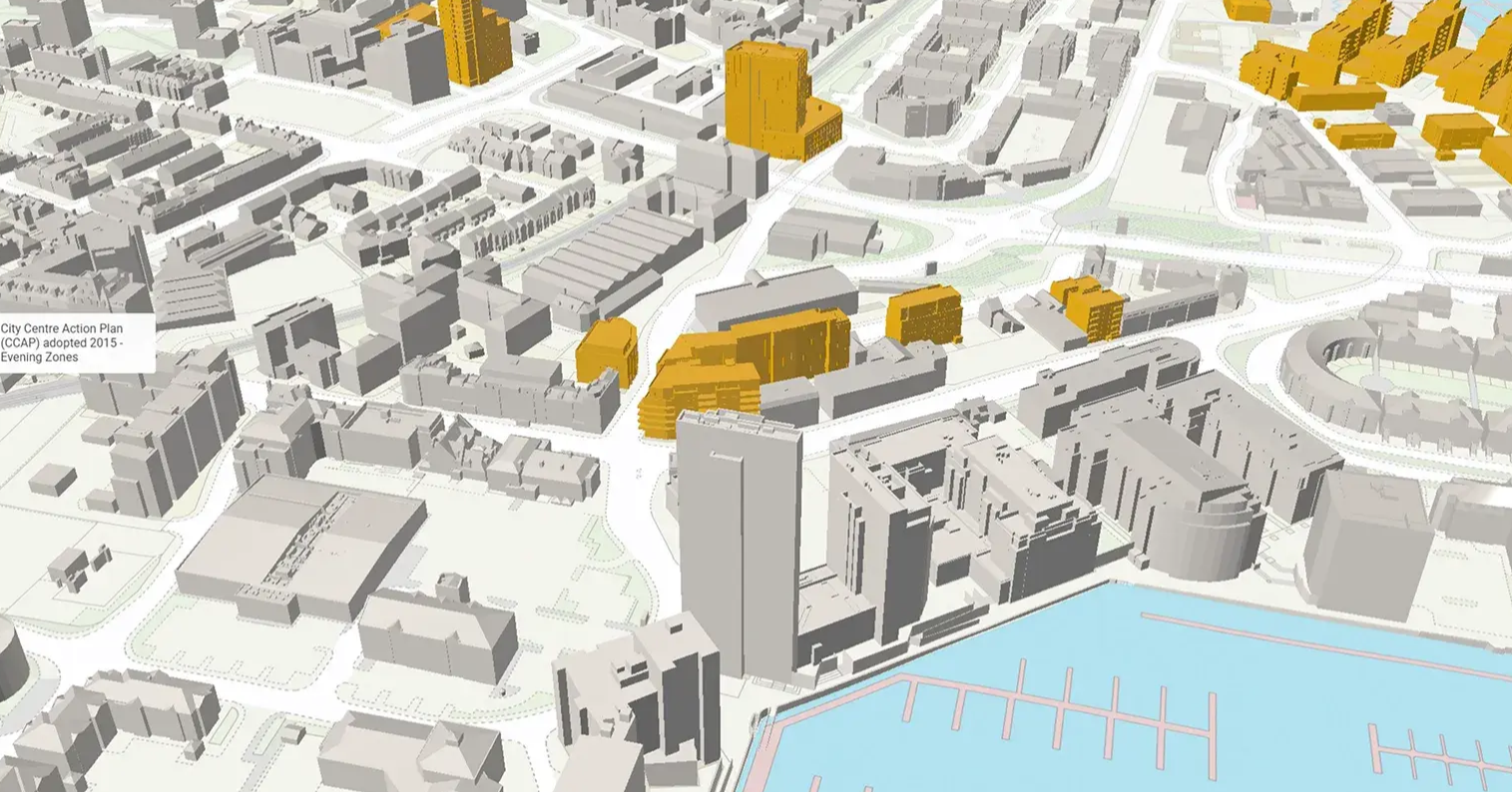
Lambeth Council sought to inform their areas appropriate for Tall Buildings, including the creation of a 3D model for each potential location, and using a 3D model of the entirety of London to examine any potential adverse heritage and townscape impacts. This process is referenced both in their Local Plan, and also their Brixton Tall Buildings Study (2018) and Waterloo Building Height Study (2018), as well as their Evidence Base for Draft Site Allocations DPD (examples here for sites at 18 Norwood Road and Knolly’s Yard). Similarly, Waltham Forest conducted an assessment of their skyline when considering their site allocations for “tall” and “taller” buildings, and were able to simulate possible proposed changes, and their impact on the current skyline, through the use of 3D modelling in their Skyline Study (2021), as part of their Evidence Base for their Local Plan.
Design Codes
With the importance of Design Codes steadily increasing as we near the adoption of the Levelling Up and Regeneration Bill (LURB), some local authorities are already exploring how 3D representations of their policies can help them visualise the impact of decisions around height, form and density, as well as respond to applications and ensure they fall into the parameters described in the Design Code.
The London Borough of Southwark has already explored the possibilities for their draft Design Code for Hatcham and Ilderton Road, under the Old Kent Road AAP. Using 3D modelling, Southwark and their consultants were able to explore the impacts of the Design Code, as well as test different heights and massings. Once adopted, the intention is for the 3D model of the Design Code to be available for applicants to allow them to use this as the masterplan maximum parameters, and for proposals to be assessed alongside the 3D representation.
Consultation
The benefits of digital technologies to support consultation have been a key focus for DLUHC over the past few years, clearly shown by their PropTech Engagement Fund Rounds. A key challenge with public consultation is the ease of understanding the proposals, allowing for meaningful engagement and feedback to be gathered.
3D visualisation can greatly help with sharing proposals and options with the public, and has been seen in use by Old Oak and Park Royal Development Corporation’s Local Plan Consultation, Southampton City Councils Reg 18 Local Plan Consultation, as well as consultations in Dacorum regarding their potential Opportunity Area in Two Waters, and Woking Borough Council’s Town Centre Masterplan - to name a few.
Development Management
Many Local Planning Authorities across England are also utilising 3D modelling to assess major planning applications, requiring that an applicant submits a 3D model.
This is being approached at a variety of stages, sometimes prior to a formal application being submitted, either during the Pre-App Process (e.g. Dacorum, Oxford, Brighton and Hove), or as part of a PPAs (e.g. City of London, Enfield).
Other Local Planning Authorities (LPAs) require a 3D model to be submitted as part of the planning application, particularly where tall buildings are being explored, or heritage impacts are being considered (e.g. Southwark, Cambridge). In some cases, the submission of a 3D model is being added to Validation requirements (e.g. Brent, Salford, Tower Hamlets), to support the planning officers in their assessments of the application.
At least seven other local planning authorities have discussed their intention to implement a requirement for 3D modelling to be provided by applicants in the near future, whether at Pre-app, or at submission of an application, and we expect others to soon join them as the benefits of reviewing proposals in 3D are fully embraced.
What Does the Future Hold?
The appetite to leverage immersive 3D technology is growing and is being supported by the Government’s digital planning agenda. The digital powers granted in the LURB shows the commitment to embedding innovative technologies into the planning system, and the use of 3D models is already growing in both scope and pace.
Our top three predictions for what the rest of 2023 holds for the use of 3D models in planning are:
- The trend is showing that we’ll see more LPAs seek to require the submission of 3D models to help them review proposals, either at Pre-App or submission of a Planning Application.
- Those LPAs who have already adopted 3D models that show them consented planning applications will be able to monitor the impact of their adopted policies, compared with schemes that then come forward.
- More LPAs will explore representing their policies in 3D form to facilitate policy making, but also increase efficiency in decision making, as planning officers can directly benefit from the use of these forms when assessing proposals.
The use of 3D digital technology in the built environment is becoming increasingly prevalent, with many Local Planning Authorities leading the way in how this type of tool can be used to develop, communicate and apply policy decisions.
In 2019 we were talking about a few trail blazers leading the way; the next phase is seeing 3D digital techniques becoming more deeply embedded, and wider spread across the sector.
If you’d like to explore more examples then click here. Alternatively, if you are a Local Planning Authority and want to discuss including more of your data into a 3D model, then contact us here.
VU.CITY Case Studies
See how leading built environment experts are using VU.CITY
-1-1-1.png)
Shape Tomorrow’s Cities, Today.
Begin Your Free Trial Now.
